| Above: This supercell thunderstorm produced hail up to baseball size near the town of Stinnett as it moved through the Texas Panhandle north of Amarillo on Monday night, May 15, 2017. Image credit: © Matt Crowther. |
Several rounds of severe thunderstorms will rumble across Tornado Alley from Tuesday afternoon to early Wednesday morning. The NOAA/NWS Storm Prediction Center tagged a belt from Iowa to Texas with an enhanced risk of severe weather in its Tuesday outlook, surrounded by a larger slight-risk area. A small part of western Oklahoma and the eastern TX panhandle was upgraded to a moderate risk in SPC’s 11:30 am update.
The entire gamut of severe weather could materialize on Tuesday, including one or more strong tornadoes, giant hail, wind gusts topping 75 mph, and extremely heavy rain. However, these threats will not be distributed evenly across the SPC risk areas.
 |
| Figure 1. WU depiction of severe weather risk guidance for Tuesday, May 16, 2017 issued by the NOAA/NWS Storm Prediction Center at 11:30 am CDT. |
Conditions appear more volatile for Tuesday than they were on Monday, which itself produced more than 140 preliminary reports of severe wind and hail, mainly over the central High Plains and Upper Midwest. A swath of deeper low-level moisture pushed north through Texas overnight and was proceeding toward the Central Plains on Tuesday. Later on Tuesday, a very potent slug of upper-level energy and cold air aloft (a short wave) will rotate around a large upper-level trough over the western U.S. The juxtaposition of the short wave and warm, moist surface air will produce a broad band of very unstable air.
As well described by SPC forecasters Roger Edwards and Greg Dial, Tuesday’s outbreak of severe weather should arrive in three distinct phases.
Central Plains cluster. The high-resolution HRRR model shows thunderstorms firing as early as mid-afternoon in southwest Kansas, on the nose of the surging moisture and just ahead of a dryline (see our dryline explainer from last Friday). These storms will likely expand into a large mesoscale convective system, bringing very heavy rain, large hail, and howling winds to northeast Kansas, eastern Nebraska, and western Iowa. As the complex matures and expands, the tornado threat should decrease, but localized flash flooding could develop—especially in parts of central and northeast Kansas, where the storms could dump 2” to 4” of rain in short order. Omaha, Des Moines, and Kansas City could get hammered by this storm complex on Tuesday night.
 |
| Figure 2. The 15Z Tuesday run of the HRRR short-range model projects a storm complex to be rolling across Kansas at 00Z Wednesday (7:00 pm Tuesday CDT), with scattered supercells over western OK and northwest TX. Image credit: tropicaltidbits.com. |
Potential tornadoes on the dryline. South of the Central Plains complex, a wedge of very warm air about 1 – 2 miles above the surface will keep a lid on thunderstorms until later in the afternoon. Eventually, daytime heating should provide enough instability to burst through the cap, especially with the approaching upper-level short wave and converging winds along the sharp dryline. Winds will veer and increase sharply with height, thus providing the strong vertical wind shear needed for supercell thunderstorms.
HRRR and other models strongly indicate that several supercells will erupt near the dryline in the eastern Texas Panhandle and race northeast at 40 to 50 mph through the moderate-risk area into western Oklahoma. Especially if they end up separated by roughly 50 to 100 miles, as suggested by the HRRR, each of these could produce multiple tornadoes, some of which may be strong. SPC has flagged the area with a 10% chance of an EF2-or-stronger tornado within 25 miles of any given point. Fortunately, these storms will quickly outrun the strongest upper-level support, and they should be on the decrease after nightfall as they approach the population corridor along Interstate 35.
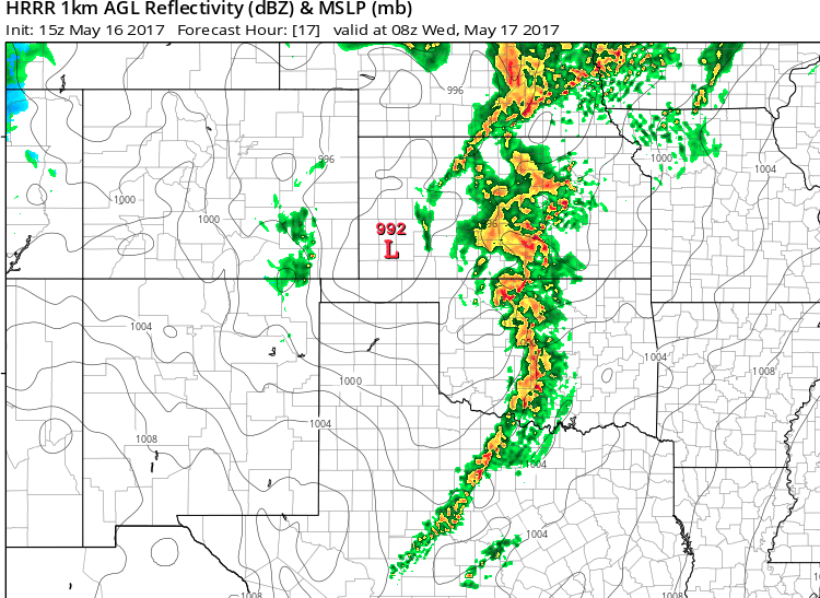
Late-night house-rattler. The core of the upper-level short wave will rip across the plains overnight, with jet-stream-level winds exceeding 110 knots (125 mph). Short-range models agree that a line of severe storms will develop after dark across western OK and TX. The HRRR and high-resolution NAM models show these storms congealing into a squall line that blasts through Wichita, Tulsa, Oklahoma City, and the Dallas-Fort Worth metro area between around midnight and 3 AM CDT. These storms could produce 1” – 3” of rain and extremely strong downburst winds. The tornado and large-hail threat should decrease over time as the cluster expands.
 |
| Figure 3. A line of strong storms will be plowing across parts of KS, OK, and TX at 08Z Wednesday (3:00 am CDT), according to the 15Z Tuesday run of the HRRR short-range model. Image credit: tropicaltidbits.com. |
More storms (and snow?!) later this week
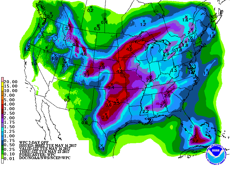
Wednesday should provide a breather from widespread severe weather, but the GFS model indicates that the main upper-level low will settle close to the Four Corners of the southwest U.S. from Thursday into Friday, bringing more storminess in many of the same areas that will be affected on Tuesday. The tornado risk may be somewhat muted by a surging cold front that will likely be cascading southward across the High Plains. Given the expected slow movement of the upper low, heavy rains could plague parts of the central U.S. through Saturday (see Figure 4).
 |
| Figure 4. Precipitation totals for the 7-day period from 7:00 am CDT Tuesday, May 16, 2017, to Tuesday, May 23. Image credit: NOAA/NWS Weather Prediction Center. |
Residents of the urban corridor near Denver are already bracing for a possible late-season snowfall. The upper low will be in a nearly ideal position for pulling easterly winds upslope against the Front Range of the Rocky Mountains. An unusually cool surface high will be pushing south from Canada, and the cold air within the upper low, together with cooling produced by heavy precipitation, may be enough to nudge the temperature profile into the wet-snow range even at the altitude of Denver and Boulder. Guidance from NOAA’s short-range SREF ensemble suggests that anywhere from 1” to 6” could fall on Thursday night in Broomfield (between Denver and Boulder), with a very small chance of even greater amounts. In the higher foothills and mountains west of Denver, a foot or more of snow is quite likely.
Just 1°C of temperature variation (impossible to pin down at this point) across the Denver area could make the difference between mixed rain and snow and a substantial accumulation. Any snowfall should melt quickly on Friday. However, many trees are leafed out, so limb loss and power outages are a distinct possibility should the snow materialize.
Snow in early May isn’t so unusual in Denver, but very few accumulating snows have occurred in the second half of May. The city has received an inch or more of snow after May 15 in only seven springs in records going back to 1881. On May 29, 1975, Denver received 5.6” of snow, and as recently as May 21, 2001, Boulder picked up 3.6”. Back on May 20-21, 1931, Boulder racked up a whopping 19”, according to Boulder climate observer Matthew Kelsch.


