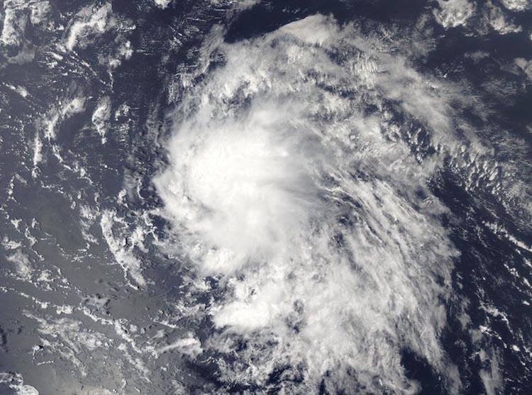
| Above: Visible-wavelength GOES-16 satellite image of Potential Tropical Cyclone 9 before it became Harvey, taken at 1515Z (11:15 am EDT) Thursday, August 17, 2017. GOES-16 data are preliminary and non-operational. The RAMMB site also has a "floater" loop zoomed in on Harvey, but this will be dark at night. Image credit: RAMMB / CIRA@CSU. |
The Atlantic’s eighth named storm of 2017, Tropical Storm Harvey, is en route to the Caribbean. Air Force Hurricane Hunters found that Harvey had gained a closed low-level circulation, with peak winds of around 40 mph, so the former Potential Tropical Cyclone 9 was upgraded to TS Harvey by the NOAA/NWS National Hurricane Center in its 5:00 pm EDT Thursday advisory. During the years 1966-2009, the average arrival date of the eighth storm of the Atlantic season was September 24—more than a month later than this year’s formation of Harvey—so 2017 is considerably more active than usual.
NHC placed Harvey’s center about 250 miles east of Barbados, and the storm was moving west at about 18 miles per hour. Harvey’s shield of showers and thunderstorms (convection) was growing and consolidating late Thursday, with an increasing amount of upper-level outflow ventilating the storm.
Upper-level winds will continue to steer Harvey westward for the next several days, which means tropical storm conditions will be possible over and near the Windward Islands as soon as early Friday morning. Tropical storm warning flags were flying late Thursday over Martinique, St. Lucia, St. Vincent and the Grenadines, and Barbados, and a tropical storm watch was in effect for Dominica.
| Figure 1. WU depiction of NHC forecast for Harvey as of 2100Z (5:00 pm EDT) Thursday, August 17, 2017. |
Outlook for Harvey
Overall, the prognosis for Harvey has changed little since our last post midday Thursday. There is very high confidence in a westward track through the Caribbean during the weekend. By Monday afternoon, Harvey is forecast by NHC to be very close to the north coast of Honduras, with a landfall projected by NHC for Tuesday along the Belize coast. Even though models agree strongly on Harvey’s general westward track, it would take only a slight departure north or south to change the landfall location significantly.
Harvey is expected to intensify only gradually over the next several days, as it is fighting off persistent easterly wind shear of 10-20 knots that’s been injecting dry air into the storm. By Sunday, the wind shear is predicted to weaken to less than 10 knots, and midlevel relative humidity in the vicinity of Harvey will rise from around 50% to the range of 65-70%. Sea surface temperatures (SSTs) will be in the range of 28-29°C (82-84°F) along Harvey’s track through the Caribbean—more than adequate for development—so the key to Harvey’s ultimate strength will be the timing of the expected drop in wind shear. If the shear decreases more quickly and/or more dramatically than expected, a period of rapid intensification cannot be ruled out. A more southerly-angled track would limit the time frame of this risk, since it would bring Harvey ashore sooner (over Nicaragua).
 |
| Figure 2. MODIS true-color satellite image of 92L on Thursday afternoon, August 17, 2017. Image credit: NASA. |
92L headed towards The Bahamas
Tropical wave 92L was located about 700 miles east-northeast of Harvey, near 15°N, 45°W, at 2 pm EDT Thursday. Satellite images on Thursday afternoon showed that 92L had increased in organization since morning, with some low-level spiral bands and upper-level outflow beginning to appear. However, heavy thunderstorm activity was quite sparse, and 92L was clearly struggling with dry air ingestion. Conditions were favorable for development through Friday morning, though, with light to moderate wind shear of 5 – 15 knots expected, an atmosphere with a mid-level relative humidity near 60%, and warm SSTs of 27.5°C (82°F). The disturbance was headed west to west-northwest at 15 - 20 mph, and will pass a few hundred miles north of the Lesser Antilles Islands on Saturday. If 92L is well enough developed, northern portions of Hispaniola may receive heavy rains from 92L beginning on Sunday morning, and this activity will reach the southeastern Bahamas and Turks and Caicos Islands on Sunday night. A continued west-northwest motion for 92L is expected into early next week, with heavy rains from the system potentially affecting eastern Cuba and the central Bahamas on Monday and Tuesday, and potentially reaching the northwestern Bahamas and Florida by Tuesday night.
The 12Z Thursday operational runs of our three reliable models for predicting tropical cyclone genesis—the GFS, European and UKMET models—had only one of the three, the UKMET, developing the system, although the HWRF model (our best at intensity) does develop and strengthen it. The 18Z Thursday run of the SHIPS model predicted that 92L would encounter high wind shear of 15 - 20 knots associated with a Tropical Upper Tropospheric Trough (TUTT) to the north on Friday and Saturday, which would likely put the brakes on development. However, by Sunday, 92L should move far enough from the shearing winds of the TUTT to see a drop in wind shear and more favorable conditions for development. In its tropical weather outlook issued at 2 pm EDT Thursday, the National Hurricane Center gave 92L 2-day and 5-day odds of development of 60%.
Elsewhere in the Atlantic
Another tropical wave is making its way through the eastern tropical Atlantic. This wave remained large but disorganized on Thursday afternoon, and it will likely take at least a day or two before it has a chance to organize into a tropical depression. NHC gives near-zero odds of this happening by Sunday, but a 30% chance by Tuesday.
Former Hurricane Gert was reclassified as a post-tropical cyclone by NHC in a 5 pm EDT Thursday update. Sustained winds are below hurricane strength, and Gert’s asymmetric structure no longer resembled that of a tropical cyclone. Gert will continue spinning down over the remote North Atlantic south of Greenland into the weekend.
Jeff Masters co-wrote this post.


