| Above: Men wade through a flooded area in the central Vietnamese province of Nghe An on Oct. 11, 2017, after floods and landslides ravaged northern and central Vietnam. Image credit: Vietnam News Agency/AFP/Getty Images. |
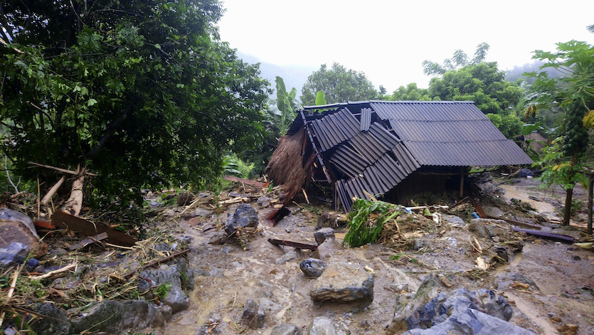
An unusual peak-of-the-season lull in tropical cyclones over the Northwest Pacific has come to an end in October, with devastating results. Central and northern Vietnam are reeling from floods and landslides in the wake of last week’s Tropical Depression 23W, which left at least 73 people dead and flooded more than 16,000 homes. The depression came ashore in central Vietnam on October 10, less than a month after Typhoon Doksuri arrived on a similar path as a Category 3–equivalent typhoon. Doksuri killed 28 people, including 17 in Vietnam, and left more than $700 million in damage, almost all in Vietnam.
The death toll from last week’s flooding was expected to rise, according to Viet Nam News. The nation’s agriculture minister was quoted as calling the floods the worst to hit Vietnam in years. One landslide on October 18 reportedly buried 19 people, although only 9 bodies had been recovered. Fortunately, the former Typhoon Khanun dissipated on Monday local time in the Gulf of Tonkin before it had a chance to strike the flood-ravaged areas in Vietnam.
 |
| Figure 1. A house sits ravaged on Oct. 13, 2017, after flash floods in the northern Vietnamese province of Hoa Binh. Image credit: Nhan Sinh/Vietnam News Agency via AP. |
An unprecedented lull in typhoons at peak season
While the Atlantic was churning out intense hurricanes one after another in September, the Northwest Pacific was notably quiet. This is a common pattern across the global tropics, mainly because of recurring phenomena that include the El Niño/Southern Oscillation (ENSO) and the Madden-Julian Oscillation (MJO). These semi-cyclic features tend to favor rising motion in one part of the tropics while suppressing it in another. Because an El Niño event can persist throughout the northern summer and fall, it can lead to an entire season being more active than usual in parts of the Pacific and more quiet than usual in the Atlantic—or vice versa during La Niña conditions, similar to what we’re seeing this fall. The MJO is a shorter-term influence, typically producing a month or so of active conditions in one region and quieter conditions in another.
The MJO favored activity in the Atlantic and greatly suppressed the Northwest Pacific during September and early October. In records going back to 1945, this was the first year that saw no active typhoons at all during the month-long peak-season period between September 16 and October 15, according to Dr. Phil Klotzbach (Colorado State University). The MJO has now shifted into a mode that supports rising motion and typhoon development in the Northwest Pacific. However, the MJO may again favor the Atlantic toward the end of October and early November. See our Tuesday morning post by Dr. Jeff Masters on the potential for Atlantic development roughly one to two weeks from now.
 |
| Figure 2. Enhanced Himiwari-8 infrared image of Tropical Storm Lan at 4:30 pm EDT Tuesday, October 17, 2017. Image credit: JMA via RAMMB / CIRA @ CSU. |
Lan could be big trouble for Japan this weekend
Tropical Storm Lan has the potential to morph into a destructive typhoon this week, and a landfall in Japan is a strong possibility. Located several hundred miles east of the southern Philippines on Tuesday, Lan was steadily strengthening, with top 1-minute sustained winds up to 70 mph at 5 pm EDT. The storm had already built a formidable central core, with pronounced banding features developing quickly. The beginnings of an eye were apparent on microwave satellite imagery.
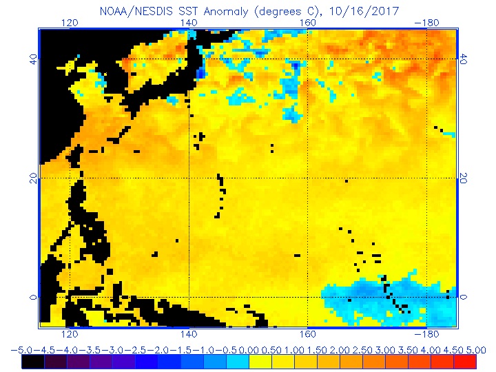
Lan will be traveling over waters unusually supportive of an intense typhoon, even by the standards of the frequently active Northwest Pacific. SSTs are 1-2°C above average throughout the area east of the Philippines (see Figure 3). These waters are so warm in part because so few tropical cyclones have been churning across them. Through Monday, the Northwest Pacific had racked up just 51% of its average year-to-date accumulated cyclone energy (ACE). As noted above, there were no typhoons between September 16 (Doksuri) and October 15 (Khanun), normally one of the most active times of the year.
 |
| Figure 3. Warmer-than-average sea surface temperatures (yellow and orange colors) cover most of the tropical Northwest Pacific on October 16, 2017. Departures from average are shown in degrees Centigrade. Image credit: NOAA/NESDIS. |
Lan will be moving northward over the next several days across very warm SSTs of 30°C (86°F), with wind shear mostly in the light to moderate range (10 -15 knots) and a very moist surrounding atmosphere (mid-level relative humidity around 75 - 80%). By late Wednesday U.S. time, Lan is predicted by the Joint Typhoon Warning Center to be the equivalent of a Category 3 hurricane, and by Thursday it could be a super typhoon (top 1-minute sustained winds of 150 mph). Given the extremely favorable conditions ahead of it, we would not be surprised to see one or more periods of rapid strengthening this week that bring Lan to the equivalent of Category 5 hurricane strength.
Lan is predicted by JTWC to be approaching southern Japan as a powerful typhoon this weekend. The 0Z and 12Z Tuesday runs of the GFS and European models bring Lan from southwest to northeast parallel to or across Japan’s main islands, including the Tokyo area, on Monday. If Lan does parallel the islands, the exact track—whether the center stays just offshore or moves inland—will make a very big difference in terms of impacts. As it approaches Japan, we can expect Lan to maintain more strength than usual, given the unusually warm SSTs extending to near Okinawa as well as an upper-level jet core that may help ventilate the storm this weekend. (A note of caution: the GFS and Euro may overestimate Lan’s strength near Japan as a result of model issues involving very strong hurricanes and typhoons moving into the midlatitudes.)


