| Above: Infrared satellite image of the tropical wave continuing to organize in the western Caribbean at 1145Z (7:45 am EDT) Friday, June 16, 2017. Image credit: NASA MSFC Earth Science Office. |
Two tropical waves—one in the western Caribbean, the other in the central tropical Atlantic—both have potential to grow into tropical storms over the next 5 or 6 days. It’s not so uncommon to get a named storm in the Atlantic during June—last year brought us Colin and Danielle, the earliest C and D storms on record—but it’s remarkable to have two potential tropical cyclones at the same time during mid-June. The next two names on the list of Atlantic storms for 2017 are Bret and Cindy.
92L may threaten the Windward Islands
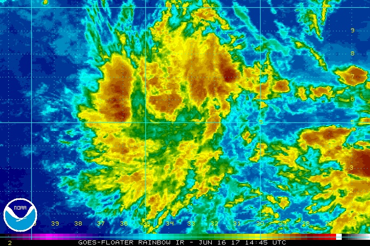
The NOAA/NWS National Hurricane Center (NHC) designated the central Atlantic wave as Invest 92L on Friday morning, which kicks off the process of tracking and forecasting this wave in greater detail. The wave was located at 8 am EDT Friday near 5°N 33°W, a few hundred miles southwest of the Cabo Verde Islands. Satellite imagery on Friday morning showed that Invest 92L was more organized than on Thursday, with a concentrated area of heavy thunderstorms developing near its core, and a modest amount of upper-level outflow becoming established.
The storm is too close to the equator for the system to leverage Earth's spin to help itself get spinning, which will make development slow to occur. Otherwise, conditions are favorable for development: the SHIPS model predicts that wind shear should remain light to moderate, dry air is expected to stay just to the north, and SSTs of 27-28°C (81-82°F) will be about 0.5°C above the seasonal norm along the wave’s track. In their 8 am EDT Friday Tropical Weather Outlook, the National Hurricane Center (NHC) gave this system 2-day and 5-day odds of tropical cyclone development (at least depression strength) of 20% and 40%, respectively—double the odds given on Thursday.
 |
| Figure 1. Enhanced infrared satellite image of Invest 92L over the central tropical Atlantic as of 1445Z (10:45 am EDT) Friday, June 16, 2017. Image credit: NOAA/NESDIS. |
Of our three top models for predicting tropical cyclone genesis, the European, GFS and UKMET models, only one--the GFS model--predicted in its 0Z Friday run that 92L would develop into a tropical depression over the next four days. Less than 10% of the European ensemble members produce a depression, while about two-thirds of the GFS ensemble members gin up 92L to depression strength, and roughly half bring it to tropical storm strength.
The 0Z Friday models had 92L maintaining a due west to slightly west-northwest track at 15 – 20 mph for the next five days, which would bring the system to the northern coast of Venezuela and into the Southern Lesser Antilles (Windward Islands) on Tuesday morning. The GFS track is slightly north of the ECMWF track, implying a higher chance of potential impacts to the islands of Trinidad and/or Grenada. The 06Z and 12Z Friday runs of the GFS brings the center near Trinidad as a mid-range tropical storm. Only one tropical storm and one hurricane have affected the Windwards or Venezuela prior to July 1 in NHC records going back to 1851.
Even if it becomes a named storm before reaching the Windwards, 92L is very unlikely to make it through the Caribbean Sea. The eastern Caribbean is a notorious “graveyard” for tropical cyclones, especially early in the season, because of persistent divergence at low levels that tends to weaken showers and thunderstorms. This divergence is the result of trade winds that are typically stronger in the central Caribbean than in the eastern Caribbean. None of the GFS and ECMWF ensemble members keep 92L as an identifiable system beyond the central Caribbean.
Gulf of Mexico in line for potential storm next week
A sprawling tropical wave in the western Caribbean is taking its time organizing. Satellite loops on Friday morning showed heavy thunderstorm activity continued over the Western Caribbean, as a large low pressure system called a “gyre” of low pressure began to form (see the website of SUNY Albany’s Phil Papin, who has developed automated routines to diagnose these gyres). This gyre is expected to move slowly west-northwest to northwest, and will be centered near the east coast of Mexico's Yucatan Peninsula on Sunday.
The interaction between this gyre and a tropical wave expected to move into the region this weekend may be enough to trigger formation of a tropical depression by early next week. However, the large size of the gyre will make it difficult for this system to intensify quickly, since it takes a long time to get such a large mass of air spinning more rapidly. NHC has raised the odds of development into a depression over the next five days from 50% yesterday to 60% today, but the odds of development over the next two days are near zero.
 |
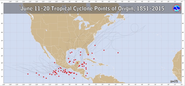
| Figure 2. A total of 29 named storms developed in the Atlantic between June 11 and 20 in Atlantic records extending from 1851 to 2015. Not shown is Tropical Storm Danielle, which formed in the Bay of Campeche on June 20, 2016. Image credit: NHC. |
Climatology favors the Western Caribbean and Southern Gulf of Mexico for development in June (see Figure 2 above). With ocean temperatures about 1°C (1.8°F) above average, at 29.5°C (85°F), along with wind shear that is predicted to be moderate, conditions will be ripe for development--if the area of low pressure manages to center itself over the water. There is plenty of land in the region to potentially interfere with development, though, and high wind shear may be an issue for the storm later in the week.
A wide range of potential landfall locations
Our best models for tropical storm genesis—the ECMWF, GFS, and UKMET—have been in impressive agreement for several days that the Western Caribbean wave will eventually become a tropical cyclone. Of the 0Z Friday ensembles, about 80% call for a tropical depression by Wednesday, and roughly half bring the system to tropical storm strength. None of the ensemble members bring the system to hurricane strength, although we can’t rule out that possibility just yet.
Where the system ends up going once it’s in the Gulf will hinge on the interaction early next week between an upper-level low pressure trough moving through the eastern U.S. and a very strong ridge of high pressure developing in the Southwest. If the trough moves more slowly, it would increase the odds of a landfall toward the central Gulf Coast, as depicted by the 06Z run of the GFS model (see Figure 3 below), whereas a faster trough motion could allow ridging to steer the system toward the Texas or Mexican coast. Any landfall on the Gulf Coast would likely be no sooner than midweek.
We’ll be back with a post on the impending Southwest U.S. heat wave later today. We will also have an update on the twin tropical threats on Saturday.
Jeff Masters co-authored this post.
 |
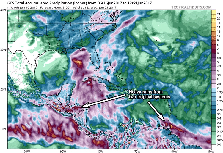
| Figure 3. Predicted total precipitation between 2 am EDT Friday, June 16, and 8 am EDT Wednesday, June 21, from the 6Z June 16 run of the GFS model. Regardless of development of the predicted low pressure gyre over the Yucatan Peninsula into a tropical depression, the large size of the low and the abundant moisture that will feed it from both the tropical Atlantic and tropical Pacific (including the remnants of Tropical Storm Calvin), will generate very heavy rains that will cause flooding and landslide concerns in portions of Central America and Southern Mexico beginning this weekend; rainfall amounts of over six inches (red colors) are predicted in Guatemala, Honduras and Southern Mexico. Note, also, the rainfall from 92L predicted to arrive in the southern Lesser Antilles Islands and northern coast of Venezuela early next week. Image credit: Levi Cowan, tropicaltidbits.com. |


