| Above: The five-day tropical weather outlook from the NHC/NOAA National Hurricane Center, issued at 2:00 pm EDT Friday, August 4, 2017, showed two areas of potential development in the Atlantic tropics. Image credit: NHC. |
It’s quite possible we will be tracking two named storms in the Atlantic basin by early next week. A tropical wave dubbed Invest 99L is spinning its way through the eastern tropical Atlantic, while another sizable wave, Invest 90L, is moving through the Caribbean. Computer models are giving both systems a reasonable chance of developing as they head west-northwest over the next few days, and both need to be watched for potential U.S. impacts.
99L taking its time organizing
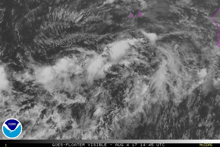
As of 8:00 am EDT Friday, 99L consisted of two weak surface lows, one around 9°N, 24°W, and the other near 10°N, 30°W. The lead wave near 30°W exhibited a good deal of spin on Thursday, but the presence of dual lows is now complicating the picture. Satellite imagery on Friday morning showed an elongated zone of disorganized showers and thunderstorms (convection) between the two centers. Because 99L is at such a low latitude, it’s more difficult for Earth’s rotation to impart a spin to the system, and the currently fractured state of 99L implies it will take time for the system to organize.
Conditions will be quite favorable for nurturing 99L over the next few days, assuming that it can consolidate around a single low-level center. Wind shear is quite low—only around 5 to 10 knots—and the 12Z Friday SHIPS model output indicates that shear will remain below 10 knots through at least Monday. 99L will be passing over sufficiently warm sea-surface temperatures of 27-28°C (82°-84°F), which is about 0.5-1.0°C above average for this time of year. The warm surface layer is not exceptionally deep, though—another reason why it may take 99L a while to organize, assuming it does. Mid-levels of the atmosphere are quite moist around 99L (70-75% relative humidity), although 99L may encounter some dry air from the Saharan Air Layer (SAL) as it heads west-northwest.
 |
| Figure 1. Visible satellite image of Invest 99L as of 1445Z (10:45 am EDT) Friday, August 4, 2017. Image credit: NOAA/NESDIS. |
Outlook for 99L
Models are in agreement that 99L will continue on a west-northwest track into early next week, heading near or just north of the Leeward Islands by Tuesday or Wednesday. Beyond that point, upper-level high pressure is projected to remain firmly in place across the North Atlantic, which implies that 99L could pose a threat to the U.S. East Coast in about 8 to 12 days. Among our three top global models for hurricane prediction, the GFS has been the most gung-ho in developing 99L, and the operational runs of the GFS from 00Z and 06Z Friday both bring a significant hurricane near the East Coast late next weekend. Our top models are far from unanimous on this idea, however. The operational runs of the European and UKMET models from 0Z Friday both keep 99L disorganized, perhaps becoming a depression or weak tropical storm at best over the next few days.
Of the 50 members of the Euro ensemble run from 0Z Friday, all 50 produce at least a tropical depression from 99L. However, most of those tracks bring a weak depression into the northeast Caribbean—a notoriously hostile environment for embryonic storms because of divergent low-level winds and sinking air. Only 2 of the 50 members depict a U.S. East Coast threat. The 20 GFS ensemble members from 0Z Friday are in far better agreement on a U.S. threat, with about 75% of the tracks recurving into or near the East Coast (though most are only at tropical-storm strength by that point). We can infer that the main question at hand is: will 99L organize beyond depression strength at all? If it does, there are ample signs that it could become a hurricane to watch, especially given its location and the time of year. (The worst Cape Verde hurricanes tend to develop from August into September.)
Our best intensity model, the HWRF, steadily develops 99L into a significant hurricane by Monday, but we should be cautious about intensity projections from HWRF (or any model, for that matter) until a distinct low-level center has formed. In its 2:00 pm EDT tropical weather outlook on Friday, the NOAA/NWS National Hurricane Center (NHC) gave 50% odds that at least a tropical depression would emerge from 99L by Sunday, and 80% odds by Wednesday.
 |
| Figure 2. Surface pressure centers analyzed in one-week forecasts issued by the 20 ensemble members of the GFS from the 2:00 am EDT Friday run, valid at 2:00 am EDT Friday, August 11, 2017. Each two-digit center should be preceded by a “10” or “9” for the predicted surface pressure in millibars. Most ensemble members produce at least a tropical depression for both Invest 99L (right) and Invest 90L (left, as discussed below). Image credit: tropicaltidbits.com |
 |
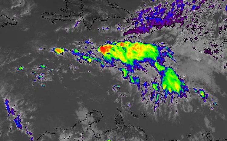
| Figure 3. GOES-16 infrared satellite image of Invest 90L as of 1700Z (1:00 pm EDT) Friday, August 4, 2017. GOES-16 data are preliminary and non-operational. Image credit: NASA/MSFC Earth Science Branch. |
90L aiming for Yucatan coast, and perhaps the Bay of Campeche
A more immediate risk is 90L, which may become a significant tropical storm or hurricane in the Gulf of Mexico early next week. The tropical wave associated with 90L extended north-south across the Caribbean Sea at around 68°W on Friday morning, with a weak surface low at its southwest end in far northern Colombia. The strongest convection was displaced well north of this center, in the central Caribbean. It is possible a new center might form closer to the convection if the showers and thunderstorms persist over the next day or two.
Over its last several runs, the operational European model has consistently developed a tropical cyclone in the far northwest Caribbean by Sunday or Monday, taken it quickly across the Yucatan Peninsula, and then strengthened it rapidly in the Bay of Campeche, with a potential hurricane landfall in northeast Mexico or southern Texas by late next week. About 75% of the Euro ensemble members show at least a depression in the northwest Caribbean by Monday, and almost 90% project a tropical cyclone moving through the Bay of Campeche later next week. Most of these runs are weaker at landfall than the Euro operational run, though. The operational GFS has been unimpressed with 90L for several runs, but there is increasing support within the GFS ensemble. Nearly all GFS ensemble members from 0Z Friday have a tropical cyclone in the western Gulf of Mexico, with some tracks angling toward the northwest Gulf Coast.
Conditions will be quite supportive for 90L by the time it reaches the northwest Caribbean. SHIPS model output from 12Z Friday indicates that sea-surface temperatures will be very warm (30°C or 86°F), with light to moderate wind shear and an extremely moist environment (mid-level relative humidity above 80%). The Bay of Campeche is a favorable spot for rapid intensification, because of its typically warm sea surface temperatures and a concave topography that helps generate atmospheric spin, so if 90L does make it across the Yucatan as a tropical cyclone, it will bear very close watching. In its 2:00 pm EDT outlook on Friday, NHC gave 20% odds that at least a tropical depression would emerge from 90L by Sunday, and 60% odds by Wednesday.
 |
| Figure 4. Infrared image of Typhoon Noru as of 1630Z (12:30 pm EDT) Friday, August 4, 2017. The south coast of Japan’s Kyushu Island is visible at top. Image credit: CIMMS/SSEC/UW-Madison. |
A weaker Noru still set to dump torrential rains on southern Japan
Typhoon Noru, formerly a Category 5 storm, was a much weaker system on Friday morning, with top sustained winds of just 75 knots (85 mph) as estimated by the Joint Typhoon Warning Center. Very strong convection was wrapping around the east side of Noru’s massive eye, however, as shown in Figure 4 above. It appears Noru has already embarked on an expected reintensification—perhaps to Category 3 status—while over the very warm waters just south of Japan, with help from a nearby upper-level jet that will help ventilate the storm.
Noru will be making a sharp turn toward the north by Saturday, and the typhoon will then accelerate across Japan’s large southern island of Kyushu on Sunday and Monday local time. Rainfall amounts could top 20” along the eastern shores of Kyushu, with heavy rains and high winds possibly extending eastward onto the southern shores of Honshu as Noru accelerates toward the north-northeast. The extreme intensification still being predicted by the European and especially the GFS model is likely overdone, because of apparent flaws in how these global models handle the oceanic environment and its interplay with the atmosphere at near-shore subtropical locations.
CSU’s August seasonal hurricane outlook: Steady as she goes
There were no significant changes to the Atlantic seasonal hurricane forecast as updated by Colorado State University on Friday. CSU meteorologists Phil Klotzbach and Michael Bell are calling for the 2017 Atlantic season to produce 16 named storms, 8 hurricanes, and 3 major hurricanes, with a seasonal accumulated cyclone energy (ACE) of 135 units. These numbers are unchanged from the team’s July 5 update, except for an increase from 15 to 16 in the anticipated number of named storms.
Klotzbach and Bell point out that the hurricane-favorable factors at play (warm waters in the tropical and subtropical Atlantic, low vertical wind shear across the deep Atlantic tropics, and the absence of El Niño) are partially negated by unusually strong wind shear over the Caribbean, as well as by cooler-than-average waters in the far North Atlantic, which tend to have a stabilizing effect on the tropics between Africa and the Lesser Antilles. “However,” they add, “we believe that the hurricane-enhancing conditions are likely to dominate this season, leading us to call for an active season.” NOAA will update its seasonal hurricane outlook on August 9.
Dr. Jeff Masters contributed to this post.


