| Above: Infrared GOES-16 satellite image of heavy thunderstorms associated with disturbance 99L at 2:30 pm EDT Friday, September 29, 2017. The disturbed weather extends north through much of the Florida peninsula. Image credit: NASA/MSFC Earth Science Branch. GOES-16 images are considered preliminary and non-operational. |
For the first time in two weeks, there are no hurricanes in the Atlantic—although the season is far from over. Tropical Storm Lee (see Figure 1 below) was downgraded from hurricane strength by the NOAA/NWS National Hurricane Center at 11 am Friday. Racing northeast at more than 30 mph across the North Atlantic, Lee was moving over waters too cool to sustain a tropical cyclone, while battling ferocious wind shear of more than 30 knots. Upper-level winds will rip into Lee’s structure and convert the storm into an elongated trough within the next day or two, thus bringing an end to the 13-plus days since Lee first became a named tropical cyclone (it was classified as a remnant for three of those days before it revived).
Following right behind Lee is Tropical Storm Maria, downgraded from hurricane strength on Thursday. At 11 am EDT, Maria was about 500 miles south-southeast of Nova Scotia and about 600 miles upstream of Lee, moving east-northeast at 27 mph. Maria was holding on to top sustained winds of 60 mph, and there may be little change in its top winds before Maria becomes a post-tropical cyclone on Saturday or Sunday. As a strong upper-level jet whisks the remnants of Lee and Maria eastward, they will both contribute to a stretch of wet, windy weather across the British Isles from late Saturday into Monday.
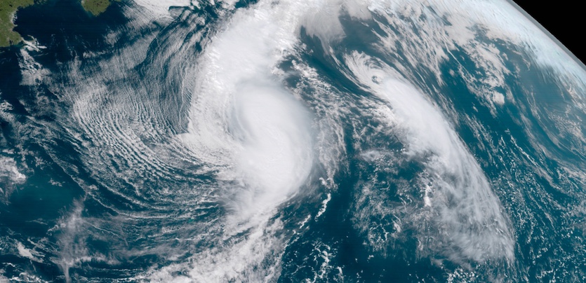 |
| Figure 1. Visible GOES-16 image of Tropical Storm Maria (center) and smaller Tropical Storm Lee (right) at 2 pm EDT Friday, September 29, 2017. Image credit: RAMMB / CIRA @ CSU |
Since we are confident no hurricanes will develop through the rest of the month, September will go down in the Atlantic books with a record total of 40 hurricane days (the total of the number of days each named storm during the month was at hurricane strength). According to Phil Klotzbach (Colorado State University), the previous record for any other month was 36.5 hurricane days, set way back in September 1926. The Atlantic database extends back to 1851, though there was most likely some undercounting of hurricane days in the pre-satellite era (before the mid-1960s).
Outlook is muddy for possible development near Florida
A broad trough of surface low pressure extending from the northwest Caribbean across Florida could hatch a tropical depression between now and Sunday. This disturbance, dubbed 99L, is associated with an upper-level low over the northeast Gulf of Mexico, and a broad area of disturbed weather lies along the trough. The strongest thunderstorms at midday Friday were streaming northward across the Caribbean just south of western Cuba.
 |
| Figure 2. Visible GOES-16 image of the broad zone of disturbed weather called 99L at 1:30 pm EDT Friday, September 29, 2017. Image credit: NASA/MSFC Earth Science Branch. |
There is only a brief window for tropical development with 99L before wind shear increases to very high levels (greater than 40 knots by late Sunday, according to the 12Z Friday run of the SHIPS model). Water temperatures are very warm (around 29°C or 84°F) and 99L is embedded in a moist atmosphere (mid-level relative humidity of around 60 – 65%). There is no clear center of circulation or dramatic spin along the trough, so it remains an open question where a depression might form. The GFS model run from 12Z Friday implies that two centers might form—one off the northeast coast of Florida, and another off its southwest coast. Less than half of the GFS ensemble members from 00Z Friday developed 99L, and those that did were equally split between the east- and west-coast solutions. About a quarter of the ensemble members end up with a tropical storm in the Gulf of Mexico. About a third of the European model ensemble members from 00Z Friday develop 99L near or over the peninsula and bring it into the northern Gulf, with only about 10% of all Euro ensemble members developing 99L into a tropical storm. None of the GFS or Euro ensemble members produce a hurricane from 99L, and all of the ensemble members from both models dissipate the system by Tuesday amid the strong wind shear.
In its tropical weather outlook issued at 2 pm EDT Friday, NHC gave 99L a 40% chance of developing into at least a tropical depression by Sunday afternoon. The odds are 40% for the five-day period as well, implying little chance that 99L would develop after Sunday.
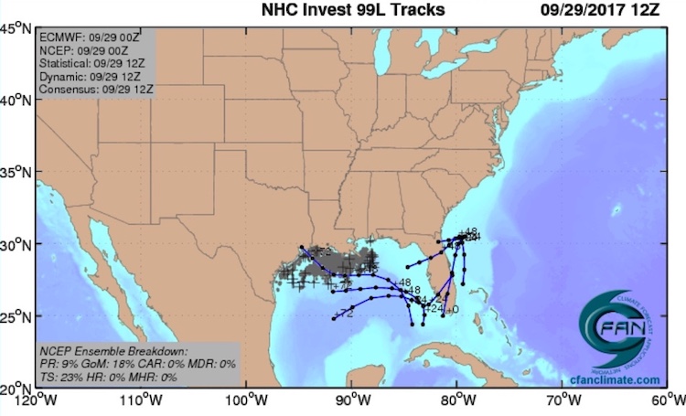 |
| Figure 3. The 20 track forecasts for 99L from the 0Z Friday, September 29, 2017 GFS model ensemble forecast. Image credit: CFAN. |
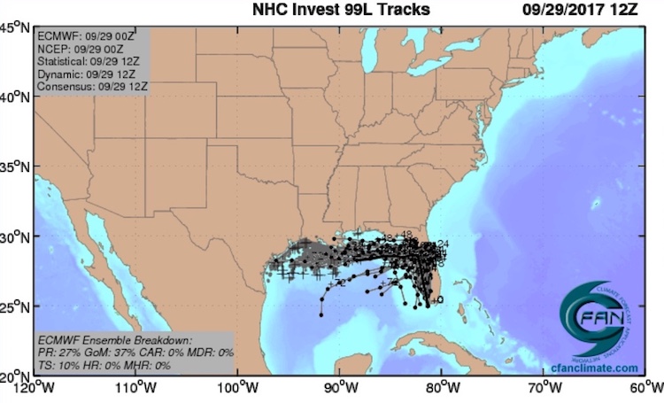 |
| Figure 4. The 50 track forecasts for 99L from the 0Z Friday, September 29, 2017 European model ensemble forecast. The track of the average of the 50 members of the European model ensemble is the heavy black line. The operational European model did not develop 99L into a tropical cyclone. Image credit: CFAN. |
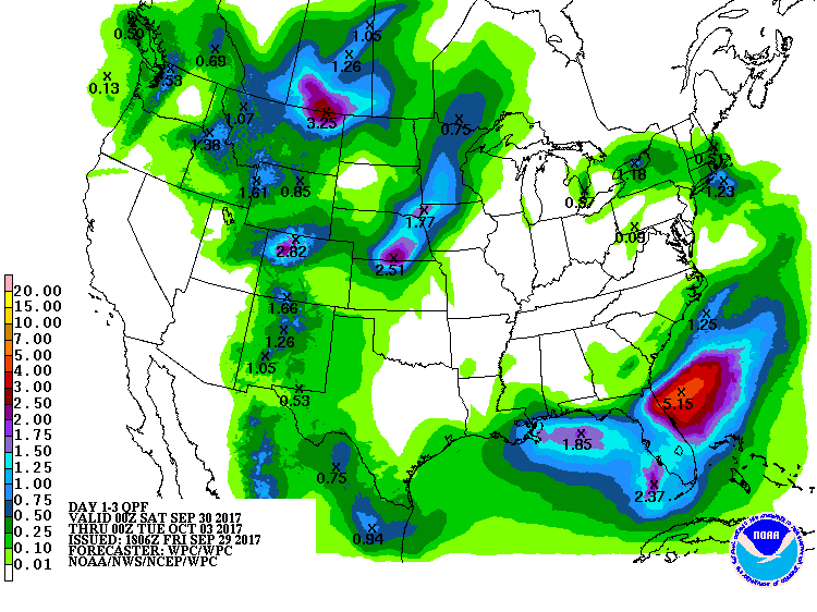 |
| Figure 5. Three-day precipitation outlook for the period from 8 pm EDT Friday, September 29, through 8 pm Monday, October 2, 2017. Image credit: NOAA/NWS/WPC. |
Heavy rain a concern for Florida and Puerto Rico
Whether or not it develops into a depression, 99L may dump several inches of unneeded rain over parts of Florida. Totals of 2 – 4” are possible along the trough, especially near the northeast and southwest coasts of Florida. If a western center were to develop and track across the northern Gulf, several inches of rain could be possible across coastal areas of Louisana and Texas later next week, but this remains highly uncertain.
Another disturbance being monitored by NHC is located over the far northeast Caribbean, close to the hard-hit northern Leeward Islands (see Figure 6 below). This disturbance is likely to remain disorganized as it moves west-northwest, with a near-zero chance of tropical depression formation through Sunday afternoon and only a 20% chance through Wednesday. However, it could still produce heavy rain over hurricane-ravaged areas from Puerto Rico to the northern Leewards. A flash flood watch was in effect Friday for Puerto Rico and the U.S. Virgin Islands, extending through late Sunday. Rainfall of 2 – 4” is possible each day. “As a result, the current flood situation will be aggravated,” warned the NWS office in San Juan.
In the extended range, the 12Z European and GFS models continue to indicate surface low pressure taking hold across the western Caribbean next week, with the risk of tropical development that could eventually move northward.
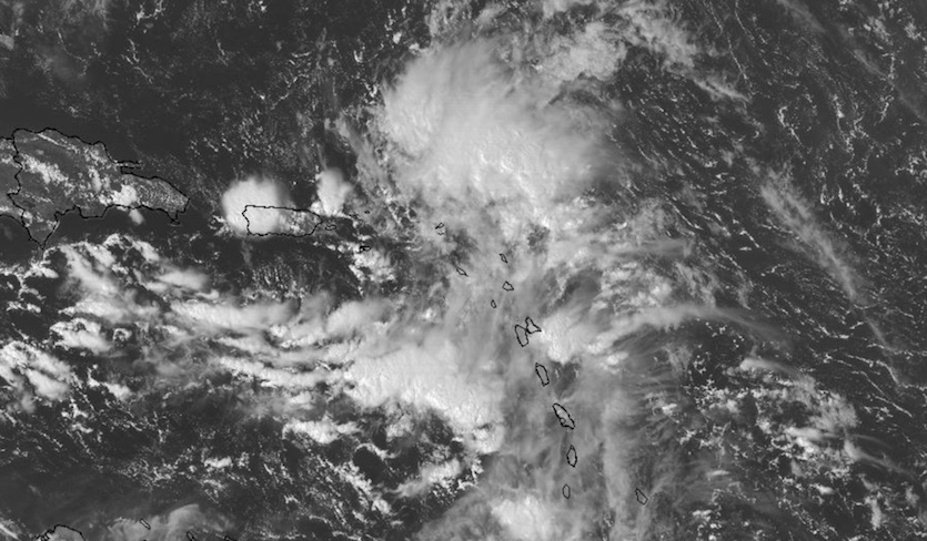 |
| Figure 6. Visible GOES-16 image of the disturbance near the northern Leeward Islands at 2:45 pm EDT Friday, September 29, 2017. Image credit: NASA/MSFC Earth Science Branch. |
Florida’s Lake Okeechobee is now at its highest level in a decade in the wake of Hurricane Irma. Any further widespread rains over the next several weeks will add to the strain on the lake’s aging Herbert Hoover Dike and its water control structures. Jeff Masters discussed the Lake Okeechobee situation at length in a post on Thursday.
Confirmed: New all-time record for U.S. rainfall from a tropical cyclone
A phenomenal 64.58” of rain observed at the Texas town of Nederland during Hurricane Harvey is the new rainfall record during a tropical cyclone at any U.S. location, according to new data released Wednesday by the National Weather Service. The 64.58” beats out the 52” recorded at a ranger station on Kauai, Hawaii, during Tropical Cyclone Hiki in August 1950.
To date, officials have found seven reliable sites that recorded more during Hurricane Harvey than the previous U.S. record. "The flooding Harvey caused from the rainfall was a historic event. For that reason alone, we need to make sure we get the rainfall amounts correct and understand how much rain actually fell," NWS forecaster Scott Overpeck told the Houston Chronicle.
Runners-up to Nederland in the most recent rainfall data compiled by NWS offices in Houston-Galveston, TX, and Lake Charles, LA, include 60.54” near Grove, LA; 56” at Friendswood, TX; and 54” near Santa Fe, TX.


