Tropical Storm Harvey, 92L Struggling
| Above: Visible-wavelength GOES-16 image of Tropical Storm Harvey at 1530Z (11:30 am EDT) Saturday, August 19, 2017. Northwesterly wind shear is blowing the tops off of Harvey’s showers and thunderstorms, as seen in the tendrils extending southeastward from the disorganized storm. GOES-16 data are preliminary and non-operational. Image credit: RAMMB/CIRA @ CSU. |
Time has not been kind to Tropical Storm Harvey, which entered the Caribbean as a minimal tropical storm on Friday. Hurricane Hunters were unable to find a closed circulation within Harvey at the 850 mb level (about a mile high) on Saturday morning. Because a closed circulation was found near the surface, the National Hurricane Center (NHC) kept Harvey classified as a tropical storm at 11 am EDT Saturday. That may be generous, as no winds above tropical-storm strength (35 knots) were found at flight level by the Hurricane Hunters. Continuity may be a factor in keeping Harvey a tropical storm, since it is likely to move into a more nurturing environment later this weekend. Update: At 11:00 pm EDT, NHC downgraded Harvey to an open wave and will be issuing no more advisories unless Harvey redevelops.
 |
| Figure 1. Radar image showing the disorganized rain showers of Tropical Storm Harvey at 11:10 am EDT August 19, 2017. Lightning strikes are shown as black squiggles. Image credit: Meteorological Department of Curacao. |
Located about 125 miles north-northeast of Curacao at 11 am EDT Saturday, Harvey was racing westward at 22 mph. Harvey’s envelope of convection (showers and thunderstorms) had become much more fragmented and elongated, a byproduct of the storm’s rapid motion coupled with persistently strong wind shear of 20-25 knots. It is possible Harvey will be stretched to the point where it loses its closed surface circulation and becomes an open wave by late Saturday. Assuming Harvey survives till Sunday, it will be moving into the western Caribbean, where wind shear is predicted by the 12Z Saturday SHIPS model to drop to the 5-10 knot range. Mid-level relative humidity should increase from around 50% to greater than 70%. This will give Harvey a much more supportive environment for strengthening. Sea-surface temperatures will remain quite warm along Harvey’s path, around 29°C (84°F)—roughly 0.5°C above average. These warm waters are quite deep, providing ample oceanic heat content to enhance strengthening if Harvey does remain a tropical cyclone.
The leading global models are in fairly good agreement on Harvey’s general track over the next 3-5 days, but subtle shifts could make a big difference in Harvey’s strength and long-term future. Most of the ensemble members from the 0Z Saturday runs of the GFS and European models take Harvey near or just north of the Honduras coast on Monday, with a landfall late Monday or Tuesday in Belize or Mexico along the east coast of the Yucatan Peninsula. A few ensemble members bring Harvey into far northern Nicaragua or eastern Honduras, in which case Harvey would likely weaken and might never reach the Yucatan. The official NHC forecast from 11 am EDT Saturday tracks Harvey into Belize as a strong tropical storm on Tuesday morning.
 |
| Figure 2. Central pressure of Harvey at 8:00 am EDT Monday, August 21, as projected by the 6Z Saturday run of the GFS ensemble modeling system. Each pair of red numerals denotes the location of Harvey’s center and the last two digits of Harvey’s central surface pressure, in millibars. Image credit: tropicaltidbits.com. |
The bulk of track guidance brings Harvey into the southern Bay of Campeche by midweek. Although it would be a weak tropical storm at best by that point, Harvey would get another chance to reintensify. It may also be tugged northward by a weak upper-level trough that will move west across the Gulf of Mexico next week. As a result, Harvey’s track could angle more to the northwest with time, with a gradual slowing in forward speed. This slowdown and the uncertainty in steering flow add a great amount of uncertainty to Harvey’s future should it reach the western Gulf later next week.
 |
| Figure 3. Invest 92L as seen by the GOES-16 satellite at 10:15 am EDT Saturday, August 19, 2017. 92L was struggling with dry air ingestion, and had a limited amount of heavy thunderstorm activity. Image credit: NOAA/CIRA/RAMMB. NOAA’s GOES-16 satellite has not been declared operational and its data are preliminary and undergoing testing. |
92L weaker as it heads towards The Bahamas
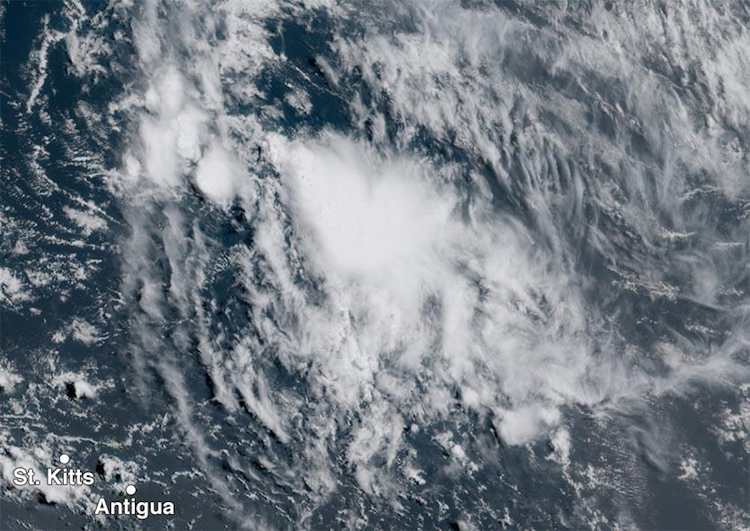
Tropical disturbance 92L was located about 300 miles east-northeast of northern Lesser Antilles Islands, near 20°N, 58°W, at 8 am EDT Saturday, and was headed west to west-northwest at 15 - 20 mph. Satellite images on Saturday morning showed that the appearance of 92L had significantly degraded since Friday, with a limited amount of heavy thunderstorm activity and little evidence of low-level spiral banding or upper-level outflow. 92L continued to struggle with dry air ingestion, as seen by arc-shaped low-level cumulus clouds moving outwards from 92L’s heavy thunderstorms. When the thunderstorms of a tropical disturbance ingest a large amount of dry air at mid-levels of the atmosphere, the resulting strong downdrafts rob the storm of moisture and hit the ocean surface with a lot of momentum, kicking up arc-shaped bands of cumulus clouds as the downdraft spreads out along the ocean surface.
Conditions were marginal for development on Saturday morning, thanks to moderately high wind shear of 15 – 20 knots from two Tropical Upper Tropospheric Troughs (TUTTs)--one located a few hundred miles northeast of 92L, and one located a few hundred miles northwest of 92L. The trough to the northwest was pumping dry air into 92L’s circulation, keeping the mid-level relative humidity a very dry 45%, which is unfavorable for development. 92L did have warm SSTs of 28.5°C (83°F) to work with, though. The disturbance will pass a few hundred miles north of Puerto Rico on Sunday, and moisture associated with 92L will bring heavier-than-usual showers and thunderstorms to Puerto Rico, the Virgin Islands, and northern portions of the Dominican Republic on Sunday afternoon and Monday afternoon. A continued west-northwest motion for 92L is expected through Wednesday, with heavy rains from the system spreading into eastern Cuba and the central Bahamas on Monday and Tuesday, and into the northwestern Bahamas and Florida on Tuesday and Wednesday.
There was little model support for the development of 92L with the 0Z Saturday cycle of model runs. None of the operational runs of our three reliable global models for predicting tropical cyclone genesis—the GFS, European and UKMET models—developed the system, and fewer than 10% of the 70 members of the 0Z Saturday GFS and European model ensembles showed 92L developing into at least a tropical depression. The 12Z Saturday run of the SHIPS model predicted that 92L might find a more favorable environment for development beginning on Sunday, though, when the system might move into a region between the two TUTTS to its north, allowing wind shear to fall to the low range, 5 – 10 knots. Wind shear is predicted to remain low to moderate, 5 – 15 knots, Sunday through Wednesday. However, the atmosphere surrounding 92L will be dry through at least Tuesday, with a mid-level relative humidity near 50%. The best chance for 92L to develop may occur on Tuesday and Wednesday, when the system will likely encounter a moister environment near Florida. In its tropical weather outlook issued at 8 am EDT Saturday, the National Hurricane Center gave 92L 2-day and 5-day odds of development of 20% and 40%, respectively. The first hurricane hunter mission into 92L is scheduled for Monday afternoon.
 |
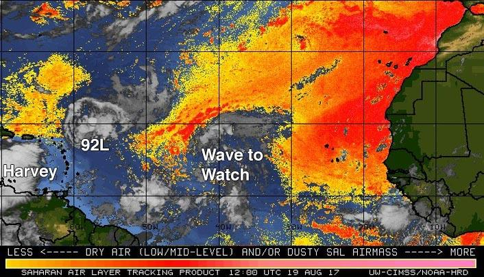
| Figure 4. The Saharan Air Layer (SAL) analysis from 8 am EDT Saturday, August 19, 2017, showed that 92L and the tropical wave to its east were encountering dry Saharan air; Tropical Storm Harvey was in a moister environment. Image credit: University of Wisconsin CIMSS/NOAA Hurricane Research Division. |
Strong tropical wave in the mid-Atlantic is no threat to land
Another tropical wave with the potential to develop into a tropical depression was located midway between the Cabo Verde Islands and Lesser Antilles Islands on Saturday morning, and was moving west-northwest to northwest at about 20 mph. Satellite images on Saturday morning showed the large wave had plenty of spin, but heavy thunderstorm activity was thin and poorly organized. Wind shear was light to moderate, 5 – 15 knots, and ocean temperatures were warm, near 27°C (81°F). The wave was beginning to encounter the dry air of the Saharan Air Layer, which was interfering with development.
As the wave heads to the northwest later in the week, it will encounter dryer air and high wind shear from a TUTT, making development unlikely. The 0Z Saturday operational runs of our three reliable models for predicting tropical cyclone genesis—the GFS, European and UKMET models—did not show development of this system over the next five days, but about 20% of the members of the 0Z Saturday GFS and European model ensembles did show development. The wave is likely to pass well to the northeast of the Lesser Antilles Islands and not threaten any land areas. In its tropical weather outlook issued at 8 am EDT Saturday, the National Hurricane Center gave this system 2-day and 5-day odds of development of 10% and 20%, respectively.
 |
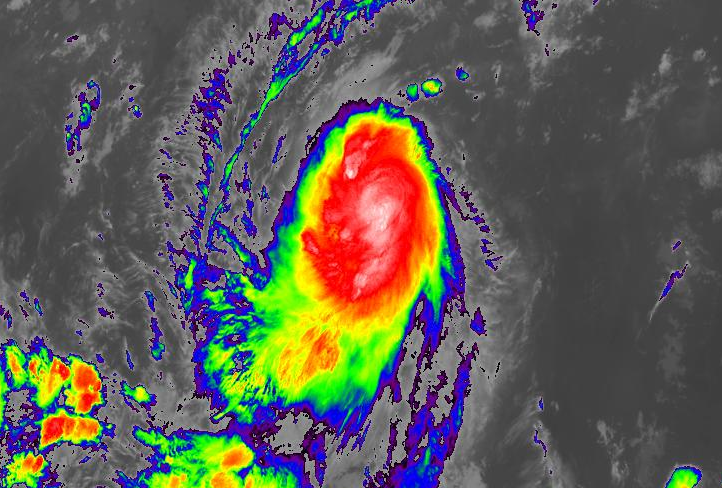
| Figure 5. Infrared GOES-16 image of Tropical Storm Kenneth at 1610Z (12:10 pm EDT) Saturday, August 19, 2017. GOES-16 images are preliminary and non-operational. Image credit: NASA/MSFC Earth Science Branch. |
Tropical Storm Kenneth forms in Northeast Pacific
The eleventh named storm of this season in the Northeast Pacific developed on Friday with the formation of Tropical Storm Kenneth roughly 1000 miles southwest of Baja California. In records for the period 1971-2009, the average date of the 11th Northeast Pacific storm was September 10, so the Northeast Pacific and the Atlantic are both more active than usual this year. Kenneth may reach Category 1 hurricane strength by Sunday, but it will eventually weaken next week while moving over cooler SSTs and angling northwest, keeping it well out to sea and no threat to land.
Jeff Masters co-authored this post.


